


Blue Marble Geo
Global Mapper
Global Mapper
Couldn't load pickup availability

Global Mapper® is a cutting-edge GIS software that provides both novice and experienced geospatial professionals with a comprehensive array of spatial data processing tools, with access to an unparalleled variety of data formats. Global Mapper's intuitive user interface and logical layout help smooth the learning curve and ensure that users will be up-and-running in no time. Organisations of any size quickly see a significant return on investment brought about by efficient data processing, accurate map creation, and optimised spatial data management.
Licence Type
| Single User Node-Locked | This license is node-locked to one computer and it cannot be access remotely. |
| Single User Floating | The Single User Floating license is remote desktop enabled (RDP), which is convenient for users working between multiple locations. |
Maintenance & Support Pricing
All new product purchases include one year of Maintenance and Support service (M&S). After an initial license purchase or renewal of M&S, users are entitled to download and license all updates to the software released within that period.
M&S also includes access to technical and licensing support. When the twelve-month period is over, users have the option to renew their M&S services, allowing them to retain their initial level of access and support.
Standard Features
- Support for importing and exporting 300+ file formats
- Access to online data sources for streaming imagery, base maps, terrain, and vector data
- Vector drawing, editing, analysis, and spatial operations
- Attribute editing, joining, calculation, graphing, and querying
- Thematic and choropleth mapping
- Map design and pre-print layout
- Lidar display, filtering, and manual editing
- Terrain creation and modification
- Terrain analysis, including contour generation, line of sight, viewshed, watershed, and flood simulation
- Volume calculation, pile volume estimation, cut and fill analysis, and change detection
- Immersive 3D visualization, 3D data creation and editing, fly-through recording, and layer animation
- Image rectification
- Image blending, feathering, cropping, and pan sharpening
- Image and raster reclassification
- Raster calculation Including NDVI, NDWI, NBR, and custom formulas
- Address geocoding
- Batch file conversion and workflow automation with Global Mapper scripts
- Integration with Global Mapper Mobile app
- GPS support for tracking and data collection
- Image blending, feathering, histogram matching, cropping and pan sharpening
NEW! added Features
- Save Favourites - Quick access to favourite scripts and online data sources are available.
- Parallel Line Generation - Parallel lines can be generated from a selected vector feature.
- Set Camera Parameters - Configure camera position, angle and heading within the 3D viewer.
- File Support Expansion - Write and read support for Cloud Optimised Point Clouds (COPC) files is now available in addition to read support for Esri SLPK.
-
Digitiser gets organised -
Experience the Digitiser’s new groove in version 26.1. The collection of vector analysis tools has been revamped into a dockable toolset. The new toolset combines the create, edit, and advanced toolbars, and can be opened from the pencil + toolbox icon found on the Tools toolbar. Similar to the original toolbars, tools that cannot be used on currently selected data will be disabled. If you would like to use the legacy view of these tools, don’t worry, all of the original toolbars are still available from the View menu.

-
Create Non-overlapping Parallel lines -
The robust Digitiser menu welcomes its newest addition, Create Parallel Lines Spaced from Selected Line Feature(s) to the Advanced Feature Creation menu. With this highly requested feature, users can select any vector to generate parallel lines from. There are options to configure the quantity of parallel lines, offset between lines, and which side of the selected line the features will be generated. The checkbox “Create Non-Overlapping Lines” adjusts the length of generated segments to prevent overlap with the parent feature, while leaving this option unchecked creates a duplicate geometry shifted to be parallel with the first segment of the line.

Use the Create Non-overlapping Lines option to determine if the parallel lines overlap or are size adjusted.
-
The Glow-Up of Spatial Online Data Source UI - The Connect to Online Data tool has long been a staple for Global Mapper users. In version 26.1, the interface received a facelift. The robust collection of built-in spatial data sources has been organised into tabs for easier navigation. Check out the ‘Popular’ tab to see some fan-favourite data sources with a small preview of the data. Sources in the Premium tab often provide higher-quality data but require accounts with a third-party vendor. For more information about a source, right-click on a source and choose Display Source Web Page/ Terms of Service.
There’s no need to search through all sources for the same one over and over again; users can now save their frequently used GIS/spatial data sources to the Favourites tab by right-clicking and selecting “Favourite Source.” Preview images can also be added to sources for easier identification. The complete collection of sources sorted by data type can still be found in the All Sources tab.
 The interface update for the Online Data tool separates sources into separate tabs for easy navigation.
If users want to add a new source to the ‘Custom’ tab, the previous action buttons have been arranged in a new File menu. Other processes moved into the file menu include: loading an image from the web, deleting cache, or saving source definitions to an XML file.
Users who need offline access to online data sources or will use Global Mapper’s analysis tools with the data need to export the relevant source(s) to a local file. In v26.1, once a source has been chosen, the Export Online Data Directly to Files option will save the data, and a step later on. An additional checkbox will import the data back into a workspace after it has been saved locally.
- Text File Import Improvements - When importing an ASCII text file, such as a .txt or .csv, the Text File Import dialog offers a selection of tools for instructing Global Mapper on how to read the file. In version 26.1, the dialog box has become more user-friendly with some radio button selections now changed to dropdown lists, improved importing with X, Y, Z columns, and support for a custom text file delimiter. In addition, users can now save text file import options and reuse settings for easy importing of similarly formatted text files. Saved options can be managed in the Configuration menu under General > Vector Formats.

-
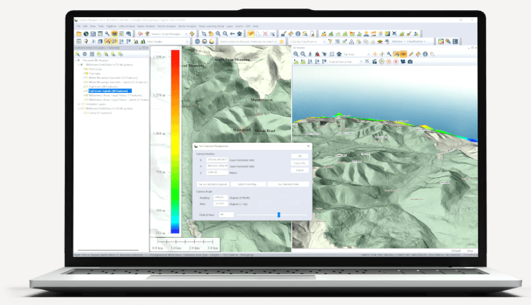
Capture your Data’s Good Side — Set 3D Camera Parameters - In version 26.1 users can configure the beloved 3D viewer even further. In addition to fan favourite tools such as simulating water rise, and flythrough, the viewer now expands the Feature Info Tool functionality. This tool is now compatible with raster and terrain data; no need to switch back to the 2D view to learn specific pixel values.
Also added in v26.1 is the ability to set camera parameters. Within the 3D views, users can specify the position of the camera from a point on the map or by entering coordinates. The angle and field of view can also be customised within the dialog box.
Features
Extensive File Format Support
No add-ons or additional licenses are needed for the support of over 300 file formats including vector, raster, elevation, and point cloud data types in Global Mapper. Users can load, combine, crop, and tile almost any data they encounter. With new and modified formats being added on an ongoing basis, you can be sure that the software will never be out of date with your data.
Connection to Online Data Sources
Streamed online data is available through Global Mapper. This wealth of sources include aerial imagery, worldwide elevation data, topographic maps, Landsat satellite imagery, land cover data, aviation charts, and much more.
Flexible Data Visualisation & Data Sharing
Global Mapper offers flexible visualisation of 2D and 3D data for optimal analysis including customisable shader. Additionally, the 3D viewer supports the recording of HD fly-through videos allowing users to export a visual exploration of point cloud, elevation, draped raster data, and vector data in an easily sharable video format.
Data can be shared in any supported geospatial format as well as through screenshots, captured videos of 3D data, and static map layouts designed for PDF export or printing with Global Mapper’s layout tools. Additional options are available for export to web tile formats from the currently loaded map data.
Vector Data Creation, Editing, and Analysis
Global Mapper supports a wide range of digitising tools including point, line, and polygon feature creation. A collection of specialised geometric tools generate range rings, grids, buffer areas, and more. Complex vector layer comparisons and feature creation can be performed with the Spatial Operations tool, featuring Intersection, Union, Difference, and Symmetrical Difference operations, along with numerous spatial predicates and transformations.
Raster Data Display and Analysis
Global Mapper offers visual adjustment tools such as multi-band data layer creation, pan sharpening, image tiling, and mosaicing. Histogram matching allows the colour channel of one layer to dictate the adjustment in others. This method along with tools for image feathering and contrast adjustments aids the blending of data layers collected at different times or with different equipment.
Raster Calculation
Raster calculation allows mathematical operations to be executed on multi-band imagery or multiple data layers. Global Mapper supports a variety of built-in formulas for NDVI, NDWI, other common indices, and custom formulas. The Raster Reclassify tool converts pixel values in a layer based on user input rules.
Terrain Creation
Dynamic terrain visualisation supports imported elevation data and TIN layers generated from 3D vector data with colourful shader options. Terrain data can be utilised to create vector layers highlighting patterns or values in the data. Elevation layers can be used to generate contour lines that can be further customised with contour interval spacing, polygon feature generation, and the identification of local peaks and depression.
Terrain Analysis
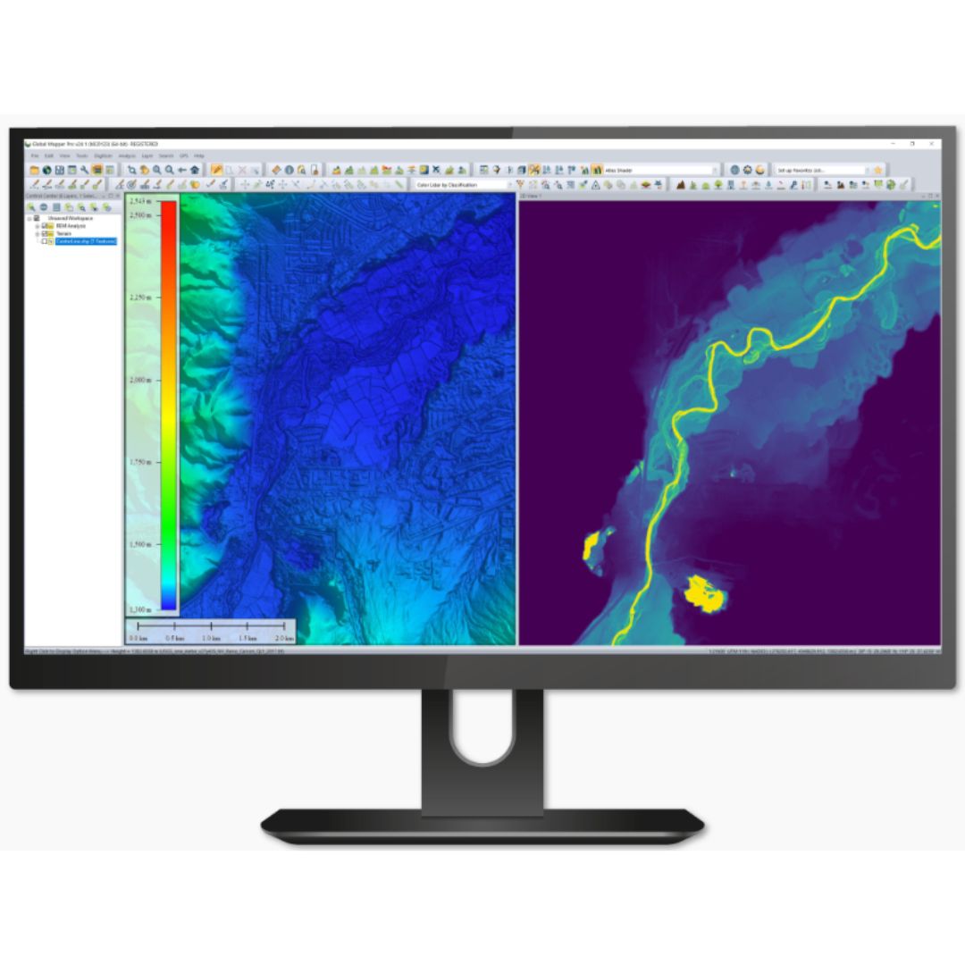
Combining vector features with terrain data offers additional options including: cut-and-fill volume calculations from polygon or linear features, flattened site plan creation, and Relative Elevation Model (REM) generation.
Watershed Analysis
Users can generate watersheds and delineate the areas to determine the likely path of streams and their drainage or catchment area. Water level-rise and potential flooding can also be assessed from a loaded terrain.
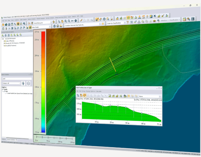
Path Profile and View-shed
Cross-section profile views of terrain can be created from any existing or drawn linear feature on the map. Profiles can be used to calculate elevation statistics and slope. Line-of-sight analysis options can be used to visualise any obstructions along the path, including 3D vector features. View-shed calculations identify the covered, or hidden, areas in all directions within a specified radius of a specified location.
Workflow Optimisation and Data Processing
Workflows can be automated by building a Global Mapper Script that supports importing, converting, reprojecting, analysing, calculating attributes, splitting layers, and exporting data. Favourite scripts can be saved for execution with the touch of a button.
To streamline a data processing workflow, Global Mapper offers a batch processing function that allows multiple selected files, or all compatible files within a specified folder, to be converted, reprojected, gridded, and renamed without rendering the data in the various viewers.