
Blue Marble Geo
Global Mapper Pro
Global Mapper Pro
Couldn't load pickup availability

Overview
Global Mapper Pro® expands upon the extensive functionality of the standard version of the application for those who need advanced GIS software solutions. You can utilise a comprehensive collection of tools for advanced 3D analysis, lidar and photogrammetric point cloud processing, drone-collected image analysis, Python scripting methods, machine-learning integration and much more. The comparison chart below shows the features and tools available in the Standard and Pro versions of Global Mapper.

Licence Type
| Single User Node-Locked | This license is node-locked to one computer and it cannot be access remotely. |
| Single User Floating | The Single User Floating license is remote desktop enabled (RDP), which is convenient for users working between multiple locations. |
Maintenance & Support Pricing
All new product purchases include one year of Maintenance and Support service (M&S). After an initial license purchase or renewal of M&S, users are entitled to download and license all updates to the software released within that period.
M&S also includes access to technical and licensing support. When the twelve-month period is over, users have the option to renew their M&S services, allowing them to retain their initial level of access and support.
PLEASE NOTE: Global Mapper Pro is an add-on to the Global Mapper Standard application. When purchasing Global Mapper Pro, you will receive two licenses—one for Global Mapper Standard and one for Global Mapper Pro. You must install both licenses to unlock the Pro features.
Features
Version 26.1 of Global Mapper Pro® includes interface changes, point cloud classification updates, and fine-tuning for vehicle detection with our robust image analysis toolset! Global Mapper’s iconic toolbar stack has been refined to include a scripting toolbar and a condensed lidar toolbar, both boasting new tools. The Lidar QC tool provides users the ability to adjust utilised GCPs to ensure the most accurate calculations Additionally, Pixels to Points® now supports 3 different Colour Harmonisation methods from openMVG.
- The Global Mapper Insight and Learning Engine (beta) - Powerful deep-learning image analysis tools for land cover classification and object detection with vehicle detection fine-tuning and custom model sharing.
- Point Cloud Classification Improvements - Updates to streamline the manual classification workflow. Addition of segmentation-based classification method for powerlines improves the accuracy and efficiency of point cloud processing.
- Split Point Cloud by Attribute - Separate point clouds into layers based on classification, point source ID, or return number
- Scripting Toolbar - Favourite Python and Global Mapper scripts can be saved for easy access and execution.

- Fine-Tuning for Vehicle Detection with Image Analysis AI Tools - Global Mapper Insight and Learning Engine™(beta) is a streamlined image analysis AI toolset. The suite of tools provides trained models for land cover classification, vehicle identification, and building extraction. Fine-tuning allows users to re-train layers of a model to improve the analysis results on specific datasets. In version 26.1, Vehicle Detection is now supported in fine-tuning and training, providing users with the ability to use their own truth data to tailor models to their needs. Other updates include improved handling of canceled training data and allowing users to easily use the same experiment name again.
- Configuration Settings for the Insight and Learning Engine - A new dedicated configuration dialog is now available for user control over models, including downloading, sharing, and updating models for image analysis. Blue Marble Geographics provides some built-in models for the Insight and Learning Engine tools, such as building and vehicle detection. Due to file size, a separate download is required. Updates for the models are provided periodically, and in v26.1 are now available for download within the Configuration menu.

Image analysis is simple with the Insight and Learning Engine’s functionality for fine-tuning for vehicle detection models.
- Ease-of-Use Updates in the Scripting Toolbar - A Scripting toolbar has been added to provide easy access to the Script Builder, Script Editor, and a new Favourite Scripts functionality. Use the Favourite Script Manager to list frequently used scripts. Running a tool or workflow is now as easy as choosing a script from the dropdown and clicking the run button. Scripting is also available in the standard version of Global Mapper, with expected functionality limitations.
- Favorite Script Manager - Accessed from the Scripting toolbar or Tools menu, the Favourite Scripts Manager provides an easy menu for managing frequently used scripts. Compatible with both Global Mapper and Python, scripts can be saved in the Favourite Scripts menu to be executed at any time.
Use the manager to choose which scripts you would like easy access to from within the Scripting toolbar. Once added to the favourites list, a copy of the script is stored in your Global Mapper library, separate from the original file. Use the tools within the Favourite Scripts tool to manage your scripts and streamline your Global Mapper workflow.

- Streamlined Lidar Tools - All of the point cloud tools in Global Mapper are now organised into one toolbar, condensing the previously separate toolbars. This new comprehensive Lidar toolbar in Global Mapper Pro contains all point cloud tools, grouped by similar functions together in mini-menus. These dropdown sections of the toolbar hold related tools for Classification and Selection. The deprecated Manual classification toolbar can still be enabled from the View menu, but those buttons have been replaced by the new Manual Classification toolset.

The Selection dropdown includes Select by Class, Select by Distance, Find Duplicate Lidar, and Select by Segment.
- New Lidar Manual Classification Toolset - In place of the Manual Classification Toolbar, the manual classification buttons have been combined into the Manual Classification toolset. A new “unclassified” classification button is also included, along with the ability to specify additional classes from the dropdown menu as shown in the image below. These additional classes can be created through the Custom Classification tool, or in the Lidar tab in Configuration.
The Manual Classification tool supports a lidar edit mode where the chosen class will be applied to any points selected while in the editing mode. This allows for continuous editing without the need for hotkeys. Additionally, as a result of the separate selection functionality, you can have multiple tools enabled simultaneously; the digitiser in the Manual classification tool can be enabled at the same time as the Path Profile tool, along with the Select by Area tool within the Path Profile window. Happen to classify the wrong points? Use Global Mapper’s trusty Undo function (ctrl + z). The new Manual Classification tool makes point cloud cleanup in Global Mapper Pro so, so easy.

All existing and new manual classification buttons are included in the Manual Classification tool.
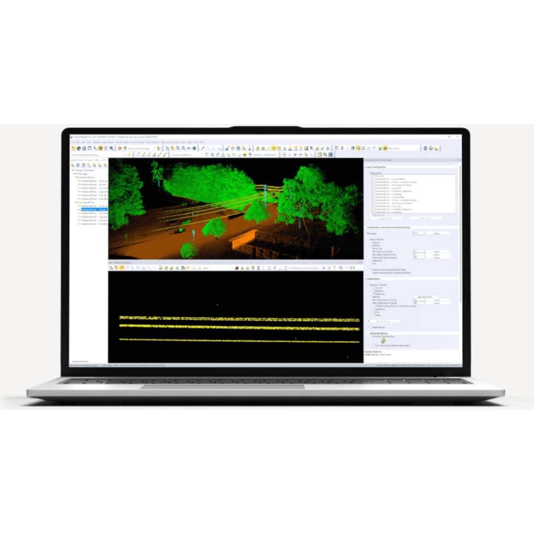
Classify Powerlines using the Maximum Likelihood Method - Maximum Likelihood is a classification method that leverages geometric segmentation to identify which class a feature is most likely to represent. This method is now available for use when identifying powerlines – providing a more advanced method for power line classification. The Maximum Likelihood method can identify linear segments within the point cloud. This gives it the strength to better discern powerlines from surrounding vegetation.

The Maximum Likelihood method can discern power line points apart from surrounding vegetation.
Point Cloud Reports -
Global Mapper Pro v26.1 includes the option to save your classification settings for future use and to view a summary report of automatic point cloud processing results. When this checkbox is enabled, a text file summary of the report will display in Global Mapper upon the completion of the classification process. This file will also be saved at the specified location, along with a .JSON file. To reimport these settings, choose the option to Enable Custom Feature Models and use the Load Models button to navigate to the .JSON file.

This provides a method of saving your settings to apply to another workspace or in the future, without having to translate them into a script file.
Standard vs Pro
Standard
Standard license includes:
|
ProAll features of standard PLUS... |
|
+ Deep-learning based image analysis via the Insight and Learning Engine. Automatically conduct land cover classification, building extraction, and vehicle detection.
|