


Air Inspect Store
DJI Matrice 400
DJI Matrice 400
Couldn't load pickup availability

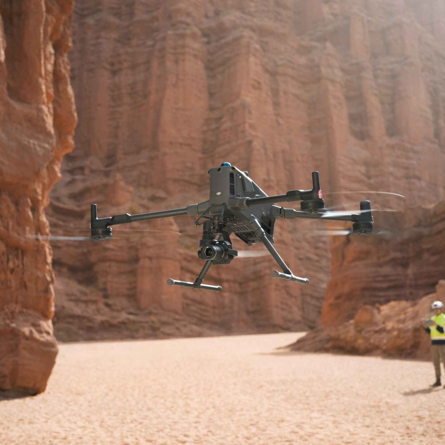
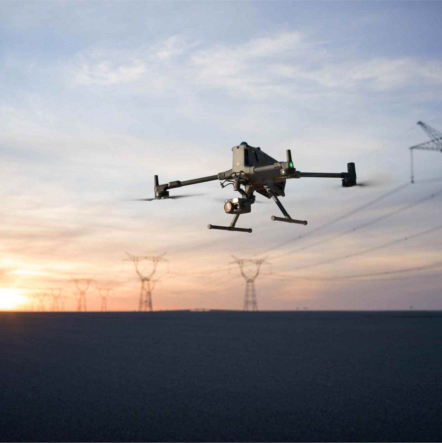
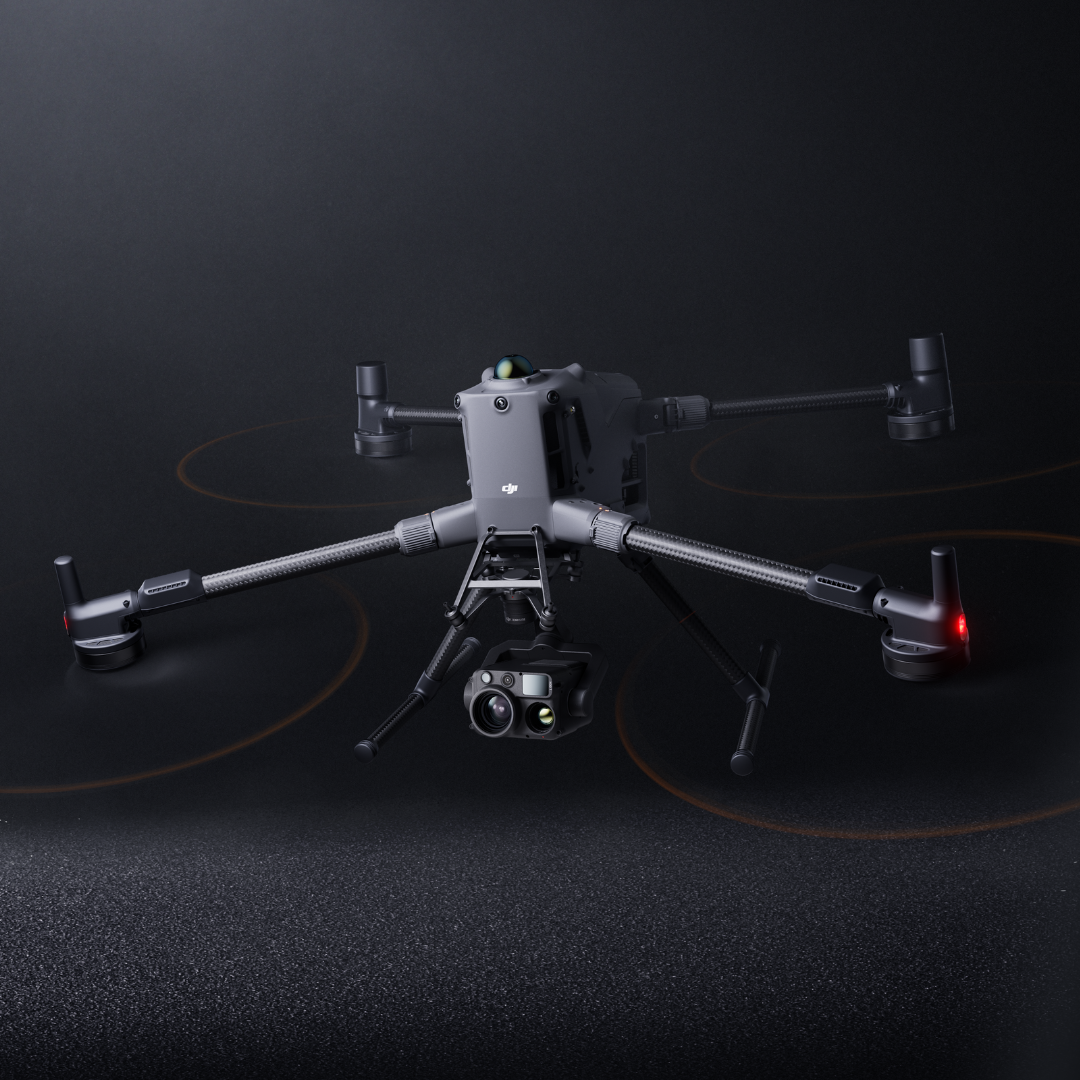
DJI Matrice 400, the enterprise flagship drone platform, boasts an impressive 59-minute flight time [1], a payload capacity of up to 6 kg [2], and integrated rotating LiDAR and mmWave radar for power-line-level obstacle sensing [3]. It also supports the O4 Enterprise Enhanced Video Transmission and Airborne Relay Video Transmission [4], ensuring safer handling and easier operations. Combining Smart Detection with visible and thermal imaging, AR projection, ship-based takeoff/landing, and advanced automation, Matrice 400 excels in emergency response, power inspections, mapping, and AEC.

Extended Flight Time, High Speed Performance - Matrice 400's flight capabilities are outstanding, offering up to 59 minutes of forward flight time even with a payload, and up to 53 minutes of hovering duration [6]. These capabilities make it a reliable tool for long-duration and continuous operations such as search and rescue, firefighting, and large-scale mapping. It can also avoid large obstacles [3] like buildings and mountains at flight speeds of up to 25 m/s.

Multi-Payload, Multi-Scene - Matrice 400’s strong payload capacity allows it to easily meet the demands of a wide range of applications. With a maximum payload capacity of 6 kg [2], Matrice 400 supports seamless switching between a single downward gimbal [8] and a dual downward gimbal [8]. It also features a third gimbal connector on the underside for additional flexibility. The aircraft is equipped with 4 external E-Port V2 ports [7], enabling simultaneous mounting of up to 7 payloads.

Depending on the task, Matrice 400 can be equipped with the Zenmuse H30 Series, L2, P1, S1 Spotlight, V1 Speaker, Manifold 3, or third-party payloads, thereby expanding its capabilities and unlocking the full potential of the DJI ecosystem.
|
|
|
|
|
Zenmuse H30 Series The Zenmuse H30 Series integrates five major modules—a wide-angle camera, a zoom camera, an infrared thermal camera, a laser range finder, and an NIR auxiliary light. Employing cutting-edge intelligent algorithms, it revolutionises perception and imaging standards, transcending the limitations of day and night vision. |
Zenmuse L2 Zenmuse L2 integrates frame-based LiDAR, a self-developed high-accuracy IMU system, and a 4/3 CMOS RGB mapping camera, providing DJI multi-payload drone platform with more precise, efficient, and reliable geospatial data acquisition. |
Zenmuse P1 Zenmuse P1 integrates a full-frame sensor with interchangeable fixed-focus lenses on a 3-axis stabilized gimbal. Designed for photogrammetry flight missions, it takes efficiency and accuracy to a whole new level. |
|
|
|
|
|
Zenmuse S1 Zenmuse S1 is DJI's first spotlight designed for multi-payload drone platforms. Utilising the LEP technology, it offers high brightness and long illumination distance, and supports multiple lighting modes. This makes it ideal for public safety, emergency rescue, inspection, and other nighttime operations.
|
Zenmuse V1 Zenmuse V1 is DJI's first loudspeaker designed for multi-payload drone platforms. It boasts high volume and long broadcast distance, and supports multiple broadcast modes, making it ideal for scenarios like public safety, emergency rescue, and more.
|
Manifold 3 Manifold 3 packs an impressive 100 TOPS of computing power into a compact unit weighing about 120 g. It can be mounted onto Matrice 400 drone platform, optimizing efficiency across various operational missions with its robust processing. |


Safe and Reliable Flight
Built for Challenging Conditions
Matrice 400 has a protection rating of IP55 [9], allowing it to operate reliably in challenging conditions including heavy dust or rain. It also maintains stable performance across temperatures from -20° to 50° C (-4° to 122° F), delivering consistent results in both hot and cold conditions.
Power-Line-Level Obstacle Sensing [3]
The Matrice 400's advanced obstacle sensing system integrates rotating LiDAR, high-precision mmWave radar, and full-colour low-light fisheye vision sensors [13], pushing detection capabilities to unprecedented levels. The system detects even small obstacles like high-voltage power lines across mountainous terrain — even in darkness [3]. It can penetrate rain and fog to sense its surroundings, providing enhanced safety in challenging weather conditions.
Enhanced Intelligence and Efficiency
Smart Detection [14]
With Zenmuse H30 Series' visible and thermal imaging, Matrice 400 can detect vehicles, vessels, and subjects during search and rescue operations or routine flights. It also supports switching to other models, enabling the expansion of application scenarios. Additionally, it supports high-res grid photos and features powerful tracking capabilities.
Power Line AR
During tasks such as power grid inspection, the obstacle sensing system automatically detects frontal wire obstacles [3] and displays easily recognisable AR lines on the remote controller’s screen, making the surrounding environment clear at a glance and ensuring safer flight.
Map View AR
When operating during the day or night in urban regions, the remote controller can display the names of buildings and landmarks in real-time, marking core roads with prominent lines.
AR Flight Waypoint
Real-time route preview is available for the drone during RTH, obstacle sensing, and FlyTo operations. During landing, the AR Aircraft Shadow can be displayed to help operators confirm the landing location.
Live Annotations
Without modelling, you can mark points on the remote controller screen to obtain subject locations, draw lines to measure distances between multiple points, and outline areas to calculate their size. Measurement results can be synchronised to the DJI FlightHub 2 to enhance team efficiency.
Specification
|
Category |
Spec |
|
|
Aircraft / Frame |
Takeoff weight (without propellers) |
5,020 ± 20 g |
|
Takeoff weight (with propellers) |
9,740 ± 40 g |
|
|
Maximum takeoff weight |
15.8 kg |
|
|
Dimensions (unfolded, L×W×H, with landing gear) |
980×760×480 mm |
|
|
Dimensions (folded, with landing gear & gimbal) |
490×490×480 mm |
|
|
Aircraft case size |
779×363×528 mm |
|
|
Maximum payload |
6 kg |
|
|
Propeller size |
25 in |
|
|
Diagonal axis distance |
1,070 mm |
|
|
Maximum ascent speed |
10 m/s |
|
|
Maximum descent speed |
8 m/s |
|
|
Maximum horizontal speed (near sea level, no wind) |
25 m/s |
|
|
Maximum service ceiling |
7,000 m |
|
|
Maximum flight time (no wind) |
59 min |
|
|
Maximum hovering time (no wind) |
53 min |
|
|
Maximum flight distance (no wind) |
49 km |
|
|
Maximum wind resistance (take-off/landing) |
12 m/s |
|
|
Maximum yaw angular speed |
100 °/s |
|
|
Maximum pitch angle |
35° |
|
|
Operating temperature |
−20° to 50°C (without solar radiation) |
|
|
Navigation / Positioning |
GNSS systems |
GPS + Galileo + BeiDou + GLONASS* |
|
Hovering accuracy (vertical, no wind / mild wind) |
±0.1 m (vision positioning), ±0.5 m (satellite), ±0.1 m (RTK) |
|
|
Hovering accuracy (horizontal) |
±0.3 m (vision), ±0.5 m (satellite), ±0.1 m (RTK) |
|
|
RTK GNSS accuracy |
Horizontal: 1 cm + 1 ppm, Vertical: 1.5 cm + 1 ppm |
|
|
RTK heading accuracy |
2° |
|
|
Ports / Connectors / Other Hardware |
USB‑C debug port |
×1, USB2.0 |
|
E‑Port V2 ports |
×4 (on bottom), each 120 W single‑port power |
|
|
Cellular dongle 2 interfaces |
×2 (on rear) |
|
|
Propeller model |
2510F |
|
|
Beacon |
Integrated |
|
|
IP rating |
IP55 |
|
|
Gimbal Capacity |
Max payload (single gimbal connector) |
1,400 g |
|
Max payload (dual gimbal connector) |
950 g |
|
|
Max payload (third gimbal connector) |
3 kg (quick release), 6 kg (screw locking) |
|
|
Sensors / Detection |
Vision system |
Omnidirectional binocular vision system (with full‑color fisheye sensors) |
|
LiDAR / 3D sensors |
Rotating LiDAR, top LiDAR, downward 3D IR distance sensor |
|
|
Millimeter‑wave radar |
6‑direction radar |
|
|
Forward measurement range |
0.4‑21 m; detection up to 200 m; FOV: 90°×90° |
|
|
Rear measurement range |
same as forward |
|
|
Side measurement range |
0.6‑21 m; detection up to 200 m; FOV: 90°×90° |
|
|
Downward measurement range |
0.5‑19 m; FOV forward/back 160°, side 105° |
|
|
Rotating LiDAR details |
0.5‑100 m @100,000 lux, 10% reflectivity; plus specs for wire detection, etc. |
|
|
Upper LiDAR (3D ToF) |
Night / >10% reflectivity: 0.5‑25 m; FOV up/down/left/right 60° each |
|
|
Downward 3D IR sensor |
0.3‑8 m; reflectivity >10%; FOV forward/back/side 60° each |
|
|
FPV Camera |
Resolution |
1080p |
|
Field of View (DFOV / HFOV / VFOV) |
DFOV: 150°; HFOV: 139.6°; VFOV: 95.3° |
|
|
Frame rate |
30 fps |
|
|
Night vision |
Starlight‑grade |
|
|
Video Transmission |
System |
DJI O4 Enterprise enhanced video transmission system |
|
Live view quality (controller) |
3‑channel 1080p/30fps |
|
|
Operating frequencies / Tx power (EIRP) |
Various: 902‑928 MHz <30 dBm (FCC), <16 dBm (MIC); 1.430‑1.444 GHz <35 dBm; 2.4‑2.4835 GHz <33 dBm etc. |
|
|
Max transmission distance (no obstacles / interference) |
40 km (FCC); 20 km (CE/SRRC/MIC) |
|
|
Max transmission distance (interference) |
Strong interference: ~1.5‑6 km; Moderate: ~6‑15 km; Light: ~15‑40 km |
|
|
Max downlink speed (standard mode) |
80 Mbps |
|
|
Battery |
Model |
TB100 |
|
Capacity |
20,254 mAh |
|
|
Nominal voltage |
48.23 V |
|
|
Max charge voltage |
54.6 V |
|
|
Cell type |
Li‑ion 13S |
|
|
Energy |
977 Wh |
|
|
Weight |
4,720 ± 20 g |
|
|
Charge temp |
5‑45 °C |
|
|
Discharge temp |
−20‑75 °C |
|
|
Battery heating support |
Single battery, on‑aircraft, and battery station all supported |
|
|
Discharge rate |
4C |
|
|
Max charging power |
2C |
|
|
Charge cycles |
400 |
|
|
Battery Station (Intelligent) |
Model |
BS100 |
|
Net weight |
11.8 kg |
|
|
Size (L×W×H) |
605×410×250 mm |
|
|
Supported batteries |
TB100 / TB100C Intelligent Flight Battery; WB37 Battery |
|
|
Operating temperature |
−20 to 40 °C |
|
|
Input (AC) |
100‑240 V, 50‑60 Hz, 10 A |
|
|
Output – for TB100 interface |
approx 1,185 W (100‑110 V), 1,474 W (110‑180 V), 2,184 W (180‑240 V) |
|
|
Output – WB37 interface |
~52 W at 100‑240 V AC |
|
|
USB‑C output |
multiple voltages: 5.0 V / 3.0 A; 9.0 V /3.0 A; 12.0 V /3.0 A; 15.0 V /3.0 A; 20 V /3.25 A |
|
|
Controller (DJI RC Plus 2 Enterprise Enhanced) |
Video transmission system |
DJI O4 Enterprise enhanced video transmission system |
|
Max transmission distance (no obstacles) |
40 km (FCC); 20 km (CE/SRRC/MIC) |
|
|
Operating frequency & Tx power (EIRP) |
see similar to aircraft spec: 902‑928 MHz, etc. |
|
|
Antenna config |
2T4R; supports 2.4 GHz / 5.8 GHz high‑gain antennas; sub‑2G modules 2T2R |
|
|
WiFi protocol / speeds |
WiFi‑Direct, wireless display, IEEE 802.11 a/b/n/ac/ax; dual‑band simultaneous; up to ~1,774.5 Mbps in 2×2 802.11ax modes |
|
|
Screen resolution |
1920×1200 |
|
|
Screen size |
7.02 in |
|
|
Frame rate |
60 fps |
|
|
Brightness |
1,400 nit |
In the box


- DJI Matrice 400 x1
- DJI RC Plus 2 Enterprise Enhanced x1
- DJI RC Plus 2 sub2G SDR Module x1
- DJI RC Plus 2 Strap and Bracket Kit x1
- DJI Matrice 400 2510F Propeller x1
- DJI Matrice 400 Gimbal Damper x1
- DJI Matrice 400 Carrying Case x1
- Rotating LiDAR Calibration Cover x1
- Front Propeller Holder x1
- Rear Propeller Holder x1
- USB-C to USB-C Data Cable x1
- WB37 Battery x1
- E-Port V2 Rubber Port Cover x2
- Rubber Plug Screws (2×2) x4
- Screws and Tools x1
- Cleaning Tools x1
Additional Accessories
Comprehensive Accessory upgrades
|
DJI RC Plus 2 Enterprise Enhanced |
DJI Cellular Dongle 2 [11] |
 TB100 Battery The TB100 Intelligent Flight Battery uses high-performance, high-energy cells and can be charged up to 400 cycles, reducing the cost per flight. It also features enhanced heat dissipation and is equipped with a self-heating system for improved reliability. |
 TB100C Tethered Battery |
|
BS100 Intelligent Battery Station The intelligent battery station is a one-stop solution for battery charging, storage, and transport. It can charge up to three TB100 batteries and two WB37 batteries sequentially. With a fast charging time of just 45 minutes [18] per TB100 battery, it ensures seamless, uninterrupted flight operations. In Silent Mode, noise levels are as low as 36 dB [19]. |
D-RTK 3 Multifunctional Station The D-RTK 3 Multifunctional Station can serve as a base station to provide centimeter-level positioning for multiple drones simultaneously. Additionally, the new Rover Station Mode, combined with the DJI Enterprise app and DJI Terra, provides a comprehensive solution for high-precision aerial surveying applications, ensuring accurate operations. |


